Summary
Using the supplied Launglon Township boundary and a 30 m D8 flow-routing grid, this analysis delineated 2,536 outlet drainage basins that intersect the township. Of these, 59 have at least 1 km² of total catchment area. A drainage network of 366 stream segments was extracted where upstream area reaches 1 km².
One basin dominates: WS0001 drains 2,024.15 km² in total, of which 365.79 km² (about 46% of the township boundary area) lies inside the township. All other basins are far smaller; most are small coastal catchments.
- 788.45 km²Township boundary area
- 778.15 km²Delineated land inside the boundary
- 2,536Drainage basins intersecting the township
- 59Watersheds ≥ 1 km² total catchment area
- 366Derived stream segments inside the township
- 0Exported catchments reaching the analysis edge (40 km buffer)
Modelled, not surveyed. Results are computed from a digital surface model at about 30 m resolution. They have not been field verified and do not delineate a catchment for any particular gauge, dam or project site. See Limitations.
Watershed map
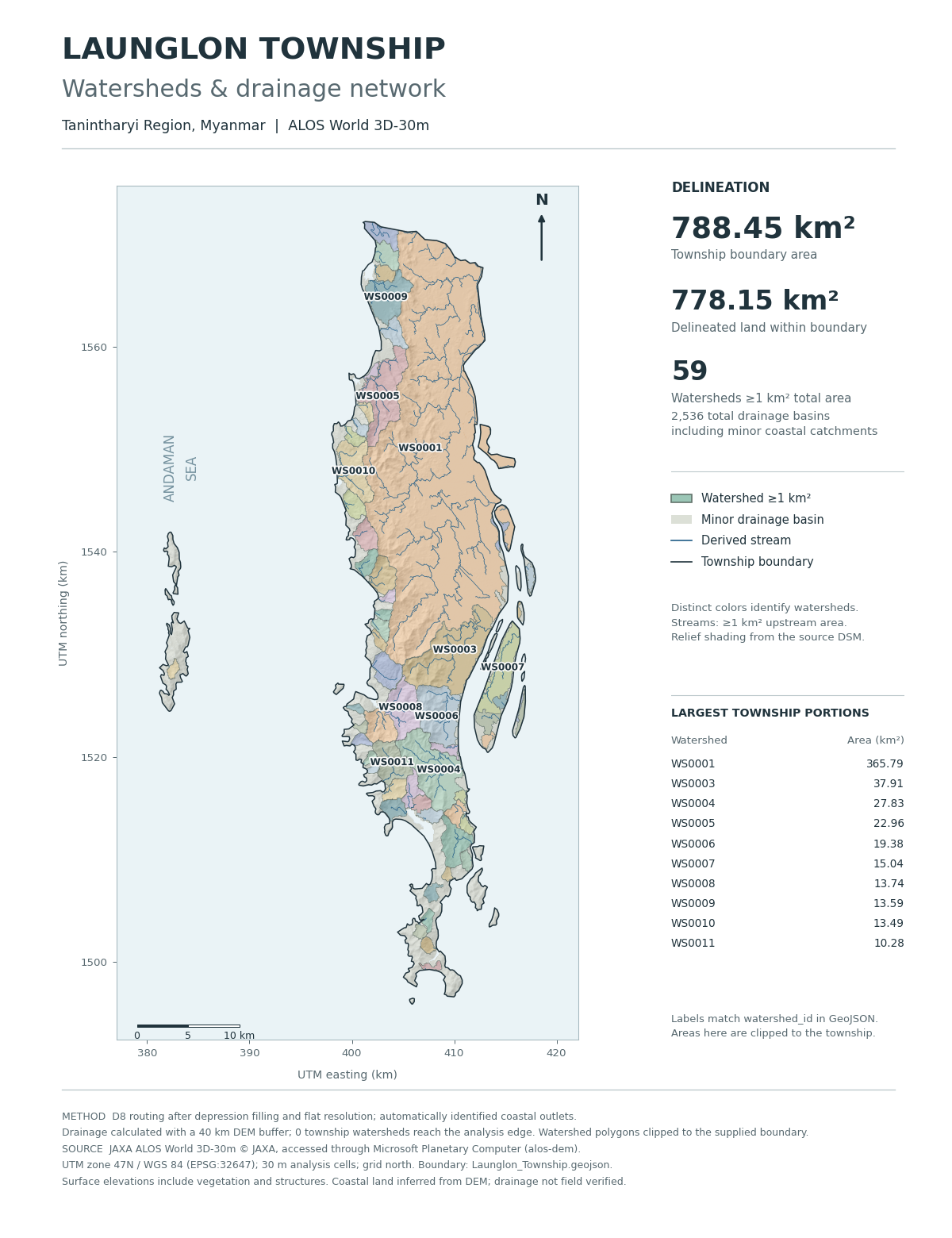
watershed_id in the GeoJSON. The publication version is 6,000 × 7,800 px at 600 dpi (10 × 13 in). Coordinates are UTM zone 47N, grid north. Open the preview image.Results
| Measure | Result |
|---|---|
| Township boundary area | 788.450637 km² |
| Delineated land inside the boundary | 778.153244 km² |
| All outlet drainage basins intersecting the township | 2,536 |
| Watersheds with ≥ 1 km² total catchment area | 59 |
| Watersheds with ≥ 1 km² inside the township | 57 |
| Derived stream segments inside the township | 366 |
| Stream initiation threshold | 1 km² upstream area |
| Final analysis buffer | 40 km |
| Exported catchments reaching the analysis edge | 0 |
Small coastal catchments remain in the GeoJSON export. The 1 km² threshold controls stream extraction and map prominence; it does not filter the watershed export. The 10.297394 km² difference between the administrative area and the delineated land reflects inferred coastal water and small fringes from the 30 m raster boundary.
A 20 km analysis buffer left one catchment touching the grid edge, so the buffer was extended to 40 km. At 40 km no exported catchment reaches the edge (grid: 5,214 × 3,892 cells).
Largest watersheds
| Watershed | Area in township (km²) | Complete catchment (km²) | Outlet (WGS 84) |
|---|---|---|---|
| WS0001 | 365.79 | 2,024.15 | 13.985° N, 98.211° E |
| WS0003 | 37.91 | 37.91 | 13.861° N, 98.201° E |
| WS0004 | 27.83 | 27.83 | 13.738° N, 98.175° E |
| WS0005 | 22.96 | 22.96 | 14.063° N, 98.078° E |
| WS0006 | 19.38 | 19.38 | 13.798° N, 98.173° E |
| WS0007 | 15.04 | 15.58 | 13.869° N, 98.219° E |
| WS0008 | 13.74 | 13.74 | 13.792° N, 98.103° E |
| WS0009 | 13.59 | 13.59 | 14.168° N, 98.090° E |
| WS0010 | 13.49 | 13.49 | 13.994° N, 98.061° E |
| WS0011 | 10.28 | 10.28 | 13.726° N, 98.103° E |
Clipped versus complete areas. Use township_area_km2 for the area inside the township and full_area_km2 for the whole catchment. Outlet points belong to the complete catchment and can lie outside the township. Areas are measured on the UTM zone 47N grid.
Method
- Boundary and elevation data. Read the supplied township boundary, then query Microsoft Planetary Computer's
alos-demcollection and download the four intersecting JAXA AW3D30 tiles. Source URLs and SHA-256 hashes are recorded; tiles are verified on every run. - Metric grid. Reproject to WGS 84 / UTM zone 47N (EPSG:32647) on a 30 m grid using nearest-neighbour resampling.
- Coastline inference. Treat cells at or below 0 m that connect to the outer sea or missing-data boundary as ocean. Isolated inland depressions are preserved. No independent coastline or water mask was used.
- Conditioning and routing. Fill depressions and resolve flats with the priority-flood algorithm in pyflwdir (Wang & Liu, 2006) to produce D8 flow directions.
- Outlet basins. Use every land drainage outlet adjoining the inferred ocean; no manual pour points were supplied. Basins are delineated on the surrounding DEM first, then clipped to the township.
- Edge test. Check every basin intersecting the township for contact with the processing edge, and widen the buffer until none touches it (20 km → 40 km).
- Streams and export. Calculate upstream area, extract streams at a 1 km² threshold with Strahler order, and export complete catchments, township-clipped polygons, outlets and streams as GeoJSON (EPSG:4326).
- Validation. Check unique identifiers, valid geometries, no substantive polygon overlap, area consistency, raster alignment and publication image dimensions.
Full details are in the methodology and validation documents.
Limitations and interpretation
- Surface model. AW3D30 is a digital surface model, so vegetation and buildings can alter inferred drainage.
- Inferred coastline. Land and sea are separated from elevation alone. Low coastal terrain and tidal drainage remain uncertain, and very small coastal catchments should be read at the dataset's ~30 m scale.
- Depression filling. Filling affected 8.18% of land cells; the 99th-percentile fill depth is 2 m and the maximum is 29 m. Rivers were not burned into the DEM.
- No field verification. There was no ground-truth survey or comparison with another DEM, so no independent accuracy estimate is available. Validation shows internal consistency, not hydrological accuracy.
- Product version. The saved Planetary Computer items do not state an AW3D30 version, and this project does not identify them as the latest JAXA release.
- Township portions. A clipped polygon is not the complete contributing catchment; use the full-extent file when upstream land outside the township matters.
Data downloads
Vector layers are WGS 84 longitude/latitude (EPSG:4326) GeoJSON and open directly in QGIS or any GIS. Use watershed_id to join polygons and outlet points.
| File | Contents | Size |
|---|---|---|
| Launglon_watersheds.geojson | Basin polygons clipped to the township boundary | 4.7 MB |
| Launglon_watersheds_full.geojson | Complete basin extents, including upstream land outside the township | 5.0 MB |
| Launglon_streams.geojson | Stream segments with contributing area and Strahler order | 0.7 MB |
| Launglon_watershed_outlets.geojson | Inferred outlet point of each complete basin | 1.0 MB |
| Launglon_Township.geojson | Input township boundary (supplied; see data terms) | 16 KB |
| analysis_metadata.json | Parameters, counts, coverage statistics and limitations | 2 KB |
| download_manifest.json | Original source URLs, sizes and SHA-256 hashes | 3 KB |
The original elevation tiles, GeoTIFF rasters, 600 dpi JPEG and PDF map are too large for ordinary Git and are excluded from the repository. They are regenerated by the reproduction workflow below, or can be packaged as a release archive as described in the publishing guide.
Reproduce the analysis
Use Python 3.12. The workflow downloads the four recorded tiles, verifies their hashes, and signs access URLs at run time; no credentials are required. Allow about 8–16 GB of RAM.
git clone https://github.com/geonet-myanmar/launglon-watershed.git
cd launglon-watershed
python -m venv .venv
source .venv/bin/activate   # Windows PowerShell: .venv\Scripts\Activate.ps1
python -m pip install -r launglon_watershed/requirements.txt
python launglon_watershed/download_dem.py
python launglon_watershed/delineate.py
python launglon_watershed/make_map.py
python scripts/validate_outputs.py --full
The initial run used Python 3.12.1 and pyflwdir 0.5.12; all direct dependencies are pinned in requirements.txt. See the reproduction guide for details.
Credits, licensing and citation
Source credit
Derived from JAXA ALOS World 3D-30m (AW3D30), © JAXA, accessed through Microsoft Planetary Computer. Product information: JAXA AW3D30. JAXA's research-data terms require source credit for public derivatives and contain conditions for commercial use.
Licensing
The project code and original documentation use the MIT license. The input boundary, source elevation data and derived geographic products have separate provenance and terms, documented in DATA_LICENSE.md. The township boundary was supplied for this analysis; its original producer and reuse terms have not yet been recorded.
Cite this project
Launglon watershed project contributors. Launglon Township watershed delineation. Analysis snapshot, 12 October 2026. https://github.com/geonet-myanmar/launglon-watershed. Machine-readable metadata: CITATION.cff.
Reference
Wang, L. & Liu, H. (2006). An efficient method for identifying and filling surface depressions in digital elevation models for hydrologic analysis and modelling. doi:10.1080/13658810500433453. Flow routing: pyflwdir.